AD 2 AERODROMES
OBBI — BAHRAIN INTERNATIONAL
OBBI AD 2.1 AERODROME LOCATION INDICATOR AND NAME
OBBI — BAHRAIN INTERNATIONAL
OBBI AD 2.2 AERODROME GEOGRAPHICAL AND ADMINISTRATIVE DATA
| 1 |
ARP coordinates and site at AD |
261615N
0503801E Mid - point of RWY on CL
|
| 2 |
Direction and distance from (city) | 3.3 NM NE of Manama |
| 3 |
Elevation/Reference temperature | 8 FT / 38° C |
| 4 | Geoid undulation at AD ELEV PSN | -83.18 FT |
| 5 |
MAG VAR/Annual change |
2.49° E
|
| 6 |
AD operator, address, telephone, telefax, e-mail address, AFS and website address |
Post: Undersecretary for Civil Aviation Tel:+973 17321100 Fax:+973 17339060 AFS:OBBIYAYX |
| 7 |
Types of traffic permitted (IFR/VFR) | IFR/VFR |
| 8 |
Remarks |
OBBI AD 2.3 OPERATIONAL HOURS
| 1 |
AD Operator | SUN - THU 04:00 - 11:15 |
| 2 |
Customs and immigration |
H24 |
| 3 |
Health and sanitation | H24 |
| 4 |
AIS Briefing Office | H24 |
| 5 |
ATS Reporting Office (ARO) | H24 |
| 6 |
MET Briefing Office | H24 |
| 7 |
ATS | H24 |
| 8 |
Fuelling | H24 |
| 9 |
Handling | H24 |
| 10 |
Security | H24 |
| 11 |
De-icing |
NIL |
| 12 |
Remarks |
NIL |
OBBI AD 2.4 HANDLING SERVICES AND FACILITIES
| 1 |
Cargo-handling facilities | BAHRAIN AIRPORT SERVICES |
| 2 |
Fuel/oil types |
Fuel: AVGAS 100 LL by prior arrangement with BAFCO (Bahrain Aviation Fuelling Company) TEL: +973 17329440 FAX: +973 17910925 Jet A1available to contract customers or on cash basis only Oil: Mobil oil Jet 2 |
| 3 |
Fuelling facilities/capacity | Jet A1 Bays C1 - C5 , E1 - E4 and 11 - 22; hydrant Bays 1 - 6 , 51 - 58, 61 - 63 and 71 - 75; Bowser AVGAS - Bowser only |
| 4 |
De-icing facilities |
NIL |
| 5 |
Hangar space for visiting aircraft |
NIL |
| 6 |
Repair facilities for visiting aircraft | Gulf Air |
| 7 |
Remarks |
1. Handling Services available H24 from Bahrain Airport Services (BAS) 2. Private / Business Aircraft shall carry a tow bar compliant to its type of aircraft |
OBBI AD 2.5 PASSENGER FACILITIES
| 1 |
Hotels | In Manama and at Airport |
| 2 |
Restaurants | At Airport |
| 3 |
Transportation | Taxis and courtesy coaches to Hotels |
| 4 |
Medical facilities | First aid; Ambulance; Hospitals in Manama |
| 5 |
Bank and Post Office | At airport; At airport |
| 6 |
Tourist Office | At airport |
| 7 |
Remarks |
NIL |
OBBI AD 2.6 RESCUE AND FIRE FIGHTING SERVICES
| 1 |
AD category for fire fighting | CAT 10 |
| 2 |
Rescue equipment | 1 rescue boat available from airport and 4 from coastguard |
| 3 |
Capability for removal of disabled aircraft | Limited |
| 4 |
Remarks | Trained personal: 18 per shift; Fire vehicles: 3 vehicles, 2 with 13000 L of capacity each, 1 with 12000 L of capacity |
OBBI AD 2.7 SEASONAL AVAILABILITY - CLEARING
| 1 |
Types of clearing equipment |
NIL |
| 2 |
Clearance priorities |
NIL |
| 3 |
Remarks |
NIL |
OBBI AD 2.8 APRONS, TAXIWAYS AND CHECK LOCATIONS/POSITIONS DATA
| 1 | Apron designation, surface and strength |
MAIN A
MAIN B: Concrete, PCN 86 / R / B /W /T MIDDLE: Concrete, PCN 112 / R / B / W / T EASTERN - 23 to 28: Concrete, PCN 89 / R / B / W / T EASTERN - 81 to 88: Asphalt, PCN 22 / F/ B / X / T WESTERN A: Concrete, PCN 119 / R / C / W / T WESTERN B: Concrete, PCN 88 / R / C / W / T EXECUTIVE: Concrete, PCN 120 / R / B / W / T CARGO: Concrete, PCN 120 / R / B / W / T NORTHERN: Asphalt, PCN 115 / F / A / W / T MENA : Concrete, PCN 24 / R / B / X / T |
| 2 | Taxiway designation, width, surface and strength |
TWY A1: 28 M, Asphalt, PCN 120 / F / A / W / T TWY A2: 25.5 M, Asphalt, PCN 105 / F / A / W / T TWY A3: 30 M, Asphalt, PCN 89 / F / D / W / T TWY A4: 31.5 M, Asphalt, PCN 113 / F / A / W / T TWY A5: 30 M, Asphalt, PCN 113 / F / A / W / T TWY A6, 22 M, Asphalt, PCN 116 / F / C / W / T TWY A7, 23 M, Asphalt, PCN 107 / F / A / W / T TWY A8: 30 M, Asphalt, PCN 120 / F / A / W / T TWY A9: 29 M, Asphalt, PCN 120 / F / A / W / T TWY B1 - Code E: 23 M, Asphalt, PCN 37 / F / B / X / T TWY B1 - Code D: 23 M, Asphalt, PCN 22 / F / B / X / T TWY K: 26 M, Concrete, PCN 64 / R / B / W/ T TWY L: 26 M, Asphalt, PCN 75 / F / A / W / T A ( B/W K & L): 26M, Asphalt,PCN 112 / F / A / W / T TWY M: 34 M, Asphalt, PCN 118 / F / B / W / T TWY N: 34 M, Asphalt, PCN 103 / F /’ B / W / T A ( B/W M & N): 25M, Asphalt, PCN 112 / F / A /W / T TWY P: 33 M, Concrete, PCN 85 / R / B / W / T TWY Q: 49 M, Concrete, PCN 56 / R / C / W / T A ( B/W P & Q): 30M, Asphalt, PCN 112 / F / A / W / T TWY R: 49 M, Concrete, PCN 87 / R / B / W / T TWY S & T : 44 M, Asphalt, PCN 72 TWY T: 42 M, Asphalt, PCN 120 / F / A / W / T TWY U & V: 42 M, Asphalt, PCN 120 / F / A / W / T TWY V: 42 M, Asphalt, PCN 120 / F / A / W / T TWY B2, 30 M, Asphalt, PCN 113 / F / A / W / T TWY Z: 63 M, Asphalt PCN 72 / F / A / X / T |
| 3 |
Altimeter checkpoint location and elevation |
Bays 11 - 19: 8 FT Bays 42 - 46: 6 FT |
| 4 |
VOR checkpoints | TBN |
| 5 |
INS checkpoints | See ACFT Parking / Docking charts |
| 6 |
Remarks |
NIL |
OBBI AD 2.9 SURFACE MOVEMENT GUIDANCE AND CONTROL SYSTEM AND MARKINGS
| 1 |
Use of aircraft stand ID signs, TWY guide lines and visual docking/parking guidance system of aircraft stands |
Taxiing guidance signs at all intersections with TWY and RWY at all holding positions. Taxi guide lines at all aprons.
|
| 2 |
RWY and TWY markings |
RWY 12L / 30R: designation, THR, Displaced THR, TDZ, CL, Edges marked and lighted RWY 12R / 30L: designation, THR, Displaced THR, TDZ, CL, Edges marked and Displaced THR & Edges lighted TWY: CL, holding positions at all TWY/RWY intersections, marked and lighted (except TWY B2). |
| 3 |
Stop bars | Where appropriate, manually controlled by TWR. |
| 4 |
Remarks | See also Aerodrome Ground Movement Chart for taxiing guidance. Road Holding positions to RWY: Reflective signs are available. |
OBBI AD 2.10 AERODROME OBSTACLES
|
In approach/TKOF areas |
In circling area and at AD | |||||
|---|---|---|---|---|---|---|
| 1 | 2 | |||||
| Obstacle identification or designation |
RWY NR/Area affected |
Obstacle type Elevation Markings/LGT |
Coordinates | Obstacle identification or designation |
Obstacle type Elevation Markings/LGT |
Coordinates |
| a | b | c | d | a | b | c |
| OB-1025 | 12L APCH |
Lamppost 11.41 M, 37.43 FT NIL / NIL |
261658.36N
0503658.50E
| OB-1127 |
Comms Mast 41.29 M , 135.46 FT NIL / NIL |
261704.32N
0503745.26E
|
| OB-2273 |
12L APCH 12R TKOF |
Building 16.27 M, 53.38 FT NIL / NIL |
261654.76N
0503706.50E
| OB-1146 |
ATC Dipole 53.56 M, 175.72 FT NIL / NIL |
261600.98N
0503751.70E
|
| OB-1234 | 12L TKOF |
ILS FFM 7.86 M, 25.79 FT NIL / NIL |
261534.71N
0503910.92E
| OB-1209 |
Comms Mast 40.85 M , 134.02 FT NIL / NIL |
261626.78N
0503856.76E
|
| OB-2130 | 12L TKOF |
Lamppost 12.46 M, 40.88 FT NIL / NIL |
261535.00N
0503920.39E
| OB-1213 |
Comms Mast 36.48 M, 119.68 FT NIL / NIL |
261523.53N
0503857.43E
|
| OB-1104 | 12L |
Lamppost 12.92 M, 42.39 FT NIL / NIL |
261654.60N
0503705.60E
| OB-1295 |
Comms Mast 56.15 M , 184.22 FT NIL / NIL |
261605.12N
0503649.33E
|
| OB-1105 | 12L |
Lamppost 12.33 M, 40.45 FT NIL / NIL |
261652.95N
0503708.24E
| OB-1321 |
Power Stn Chimney 68.21 M, 223.78 FT NIL / NIL |
261306.68N
0503932.70E
|
| OB-1106 | 12L |
Lamppost 12.40 M, 40.68 FT NIL / NIL |
261652.55N
0503709.23E
| OB-2011 |
Water Tower 46.32 M 151.97 FT NIL / NIL |
261650.15N
0503833.33E
|
| OB-1107 | 12L |
Lamppost 12.32 M, 40.42FT NIL / NIL |
261652.24N
0503710.26E
| OB-2024 |
Comms Mast 39.99 M, 131.2 FT NIL / NIL |
261611.61N
0503915.02E
|
| OB-1109 | 12L |
Lamppost 12.20 M, 40.03FT NIL / NIL |
261652.06N
0503711.30E
| OB-2072 |
Building 77.30 M, 253.61 FT NIL / NIL |
261725.96N
0503954.66E
|
| OB-1115 | 12L |
Tree 7.50 m, 24.61 FT NIL / NIL |
261650.53N
0503711.82E
| OB-2078 |
Crane (T) 95.81 M, 314.33 FT NIL / NIL |
261704.89N
0503951.69E
|
| OB-2269 | 12L |
Building 18.62 M, 61.09 FT NIL / NIL |
261657.46N
0503704.07E
| OB-2165 |
Crane (T) 191.90 M, 629.59 FT NIL / NIL |
261326.11N
0503633.69E
|
| OB-2270 | 12L |
Building 18.65 M, 61.19 FT NIL / NIL |
261657.24N
0503704.26E
| OB-2166 |
Crane (T) 201.55 M, 661.25 FT NIL / NIL |
261324.31N
0503632.51E
|
| OB-2272 | 12L |
Building 17.59 M, 57.71 FT NIL / NIL |
261655.33N
0503707.41E
| OB-2233 |
Building 82.29 M, 269.98 FT NIL / NIL |
261445.33N
0503606.04E
|
| OB-5115 | 12L |
Mobile Obstacle 6.47 M, 21.23 FT NIL / NIL |
261651.07N
0503710.26E
| OB-2235 |
Crane (T) 252.40 M, 828.07 FT NIL / NIL |
261427.54N
0503421.34E
|
| OB-5116 | 12L |
Mobile Obstacle 6.38 M, 20.93 FT NIL / NIL |
261650.35N
0503711.51E
| OB-2240 |
Financial Harbour Building 266.57 M, 874.56 FT NIL / NIL |
261415.86N
0503421.56E
|
| OB-1018 | 30R TKOF |
Lamppost 11.57 M, 37.96 FT NIL / NIL |
261659.85N
0503651.62E
| OB-2241 |
Financial Harbour Building 266.74 M, 875.12 FT NIL / NIL |
261415.89N
0503427.61E
|
| OB-1048 | 30R TKOF |
Lamppost 11.52 M, 37.79 FT NIL / NIL |
261653.00N
0503646.81E
| OB-2242 |
WTC Building 246.81 M, 809.73 FT NIL / NIL |
261422.26N
0503453.85E
|
| OB-1197 | 30R |
DVOR Monitor 8.584 M, 28.15 FT NIL / NIL |
261531.38N
0503916.68E
| OB-2243 |
WTC Building 247.07 M, 810.59 FT NIL / NIL |
261421.81N
0503453.14E
|
| OB-1247 | 12R TKOF |
Tree 10.46 M, 34.32 FT NIL / NIL |
261527.67N
0503916.88E
| OB-2249 |
Building Antenna 206.60 M, 677.81 FT NIL / NIL |
261346.40N
0503331.13E
|
| OB-1248 | 12R TKOF |
Tree 9.62 M, 31.56 FT NIL / NIL |
261527.23N
0503916.61E
| OB-2250 |
Building Antenna 206.51 M, 677.52 FT NIL / NIL |
261350.69N
0503331.27E
|
| OB-1272 | 12R TKOF |
Lamppost 8.19 M, 26.87 FT NIL / NIL |
261523.70N
0503909.89E
| OB-2261 |
Building Antenna 213.23 M, 699.56 FT NIL / NIL |
261412.06N
0503259.14E
|
| OB-2121 | 12R TKOF |
Lamppost 16.64 M, 54.59 FT NIL / NIL |
261516.53N
0503924.54E
| OB-2299 |
Flag Pole 52.35 M, 171.75 FT NIL / NIL |
261556.95N
0503545.28E
|
| OB-2122 | 12R TKOF |
Lamppost 16.58 M, 54.4 FT NIL / NIL |
261516.95N
0503922.10E
| OB-2309 |
Building 52.09 M, 170.9FT NIL / NIL |
261547.74N
0503545.31E
|
| OB-2144 | 12R TKOF |
Lamppost 11.72 M, 38.45 FT NIL / NIL |
261526.28N
0503920.36E
| |||
| OB-2145 | 12R TKOF |
Lamppost 11.86 M, 38.91FT NIL / NIL |
261525.34N
0503920.08E
| |||
| OB-5206 | 12R TKOF |
Mobile Obstacle 6.45 M, 21.16 FT NIL / NIL |
261530.03N
0503913.81E
| |||
| OB-5761 | 12R TKOF |
Mobile Obstacle 6.27 M, 20.57 FT NIL / NIL |
261526.99N
0503905.27E
| |||
| OB-1093 | 30L TKOF |
Apron Light 23.14 M, 75.92 FT NIL / NIL |
261633.28N
0503707.18E
| |||
| OB-1094 | 30L |
Apron Light 23.19 M, 76.08 FT NIL / NIL |
261634.49N
0503708.04E
| |||
| OB-1095 | 30L TKOF |
Apron Light 15.14 M, 49.67 FT NIL / NIL |
261635.67N
0503708.88E
| |||
| OB-1213 | 30L |
Comms Mast 36.48 M, 119.68 FT NIL / NIL |
261523.53N
0503857.43E
| |||
| OB-5760 | 30L |
Mobile Obstacle 6.21 M, 20.37 FT NIL / NIL |
261530.23N
0503859.66E
| |||
OBBI AD 2.11 METEOROLOGICAL INFORMATION PROVIDED
| 1 |
Associated MET Office | BAHRAIN MET. See also GEN 3.5.1.4 |
| 2 |
Hours of service MET Office outside hours |
H24. See also GEN 3.5.1.4 NIL |
| 3 |
Office responsible for TAF preparation Periods of validity |
BAHRAIN MET HR 30 |
| 4 |
Trend forecast Interval of issuance |
Trend 1/2 HR |
| 5 |
Briefing/consultation provided | Personal consultation, partial self briefing, telephone to Forecaster. See also GEN 3.5.1.5 |
| 6 |
Flight documentation Language(s) used |
Charts, abbreviated plain language text English |
| 7 |
Charts and other information available for briefing or consultation | S, U25, P25 (other levels on request), T, SWH (East & West), SWM (MID), TB (Gulf sector winds). See also GEN 3.5.1.5 |
| 8 |
Supplementary equipment available for providing information | Telefax, Self briefing terminal. See also GEN 3.5.1.5 |
| 9 |
ATS units provided with information | BAHRAIN TWR, APC, ACC, RCC |
| 10 |
Additional information (limitation of service, etc.) |
See GEN 3.5.1 |
OBBI AD 2.12 RUNWAY PHYSICAL CHARACTERISTICS
|
Designations RWY NR |
TRUE & |
Dimensions of RWY(M) | Strength (PCN) and surface of RWY and SWY |
THR coordinates RWY end coordinates THR geoid undulation | THR elevation and highest elevation of TDZ of precision APP RWY |
|---|---|---|---|---|---|
| 1 | 2 | 3 | 4 | 5 | 6 |
| 12L | 123° / 120° | 3964 x 60 |
108 / F / A / W / T Asphalt between landing THRs 120 / R / B / W / T Concrete first 307 M |
Landing THR: 261644.34N 0503710.28E THR end: 261649.67N 0503701.03E -90.38 FT | 7.55 FT 8.63 FT |
|
30R | 303° / 300° | 3964 x 60 |
108 / F / A / W / T Asphalt between landing THRs 113 / R / B / W / T Concrete first 307 M |
Landing THR: 261545.62N 0503852.03E THR end: 261540.28N 0503901.28E -90.38 FT | 7.35 FT 7.35 FT |
| 12R | 123° / 120° | 2530 x 45 |
113 / F / A / W / T Asphalt |
Landing THR: 261610.74N 0503755.62E THR end: 261616.13N 0503746.29E -90.38 FT | 8.04 FT 8.04 FT |
|
30L | 303° / 300° | 2530 x 45 |
113 / F / A / W / T Asphalt |
Landing THR: 261533.91N 0503859.44E THR end: 261531.79N 0503903.10E -90.38 FT | 6.76 FT6.46 FT |
|
Note: RWY 12R / 30L is not an active Runway. In exceptional circumstances, ATC may assign RWY 12R / 30L provided that the procedures are in place and Runway 12L / 30R is deactivated. Approaches to land or take off on RWY 12R / 30L shall not be planned without specific authorization from BCAA. Note: RWY 12R / 30L is approved as a backup RWY. Approaches to land or take off shall not be planned. RWY 12R / 30Lwill be assigned by ATC in exeptional circumstances. | |||||
| Slope of RWY-SWY |
SWY dimensions (M) | CWY dimensions (M) | Strip dimensions (M) | OFZ | Remarks | ||
|---|---|---|---|---|---|---|---|
| 7 | 8 | 9 | 10 | 11 | 12 | ||
| 12L | 0.0% |
NIL |
NIL |
NIL | 4084 x 300 | Yes | Non load bearing shoulders 8 M; RWY is liable to be slippery when wet |
|
30R | 0.0% |
NIL |
NIL |
NIL | 4084 x 300 | Yes | Non load bearing shoulders 8 M; RWY is liable to be slippery when wet |
| 12R | 0.0% |
NIL |
NIL | 60 x 150 | 2650 x 150 | No | Non load bearing shoulders 7.5 M |
|
30L | 0.0% |
NIL |
NIL | 600 x 150 | 2650 x 150 | No | Non load bearing shoulders 7.5 M |
|
Note: Standard RESA 240 M available for RWY 12L and 30R | |||||||
OBBI AD 2.13 DECLARED DISTANCES
|
RWY Designator |
TORA (M) |
TODA (M) |
ASDA (M) |
LDA (M) |
Remarks |
|---|---|---|---|---|---|
| 1 | 2 | 3 | 4 | 5 | 6 |
| 12L | 3964 | 3964 | 3964 | 3657 |
NIL |
|
30R | 3964 | 3964 | 3964 | 3657 |
NIL |
| 12R | 2530 | 2590 | 2530 | 2222 |
NIL |
|
30L | 2530 | 3130 | 2530 | 2410 |
NIL |
OBBI AD 2.14 APPROACH AND RUNWAY LIGHTING
|
RWY Designator |
APCH LGT type LEN INTST |
THR LGT colour WBAR |
VASIS (MEHT) PAPI |
TDZ, LGT LEN |
RWY Centre Line LGT Length, spacing, colour, INTST |
RWY edge LGT LEN, spacing, colour INTST |
RWY End LGT colour WBAR |
SWY LGT LEN (M) colour |
Remarks |
|---|---|---|---|---|---|---|---|---|---|
| 1 | 2 | 3 | 4 | 5 | 6 | 7 | 8 | 9 | 10 |
| 12L | ICAO CAT II precision approach lighting system 900 M LIH | Green | PAPI LEFT 3° 67.15FT | 900 M | White LIH 3964 M; 30 M white; 3000 M - 3600 M red / white; from 3600 M red LIH | White LIH 3964 M; 60 M; last 600 M yellow | Red |
NIL |
NIL |
|
30R | ICAO CAT II precision approach lighting system 900 M LIH | Green | PAPI LEFT 3° 67.15 FT | 900 M | White LIH 3964 M; 30 M white; 3000 M - 3600 M red / white; from 3600 M red LIH | White LIH 3964 M; 60 M; last 600 M yellow | Red |
NIL |
NIL |
| 12R | Simple approach lighting system (for non-instrument RWY) 420 M | Green | PAPI LEFT 3° 70.4 FT |
NIL |
NIL | White LIH 2530 M; 60 M; last 600 M yellow | Red |
NIL |
NIL |
|
30L | Simple approach lighting system (for non-instrument RWY) 420 M | Green | PAPI LEFT 3° 70.4 FT |
NIL |
NIL | WHITE LIH 2530 M; 60 M; last 600 M yellow | Red |
NIL |
NIL |
|
Note: RWY incursion lights (wig wag) installed at all TWY / RWY intersections 2.6 M from TWY edge. Height 65 CM.. | |||||||||
OBBI AD 2.15 OTHER LIGHTING, SECONDARY POWER SUPPLY
| 1 |
ABN/IBN location, characteristics and operational hours |
NIL |
| 2 |
LDI location and LGT Anemometer location and LGT |
NIL 350 M WSW of THR 30R; lighted |
| 3 |
TWY lighting | Green CL , Runway intersections |
| 4 |
Secondary power supply/switch-over time | - SECONDARY POWER SUPPLY TO ALL AD LIGHTING : 5 SECONDS. - DURING CAT II OPERATION, STANDBY GENERATOR SWITCH-OVER TIME 1 SECOND |
| 5 |
Remarks | Apron: Blue Apron edge, TWY " B1 " is a solar powered blue edge light. |
OBBI AD 2.16 HELICOPTER LANDING AREA
| 1 |
Coordinates TLOF or THR of FATO Geoid undulation |
NIL |
| 2 |
TLOF and/or FATO elevation M/FT |
NIL |
| 3 |
TLOF and FATO area dimensions, surface, strength, marking |
NIL |
| 4 |
True BRG of FATO |
NIL |
| 5 |
Declared distance available |
NIL |
| 6 |
APP and FATO lighting |
NIL |
| 7 |
Remarks | As directed by ATC |
OBBI AD 2.17 ATS AIRSPACE
| 1 |
Designation and lateral limits |
BAHRAIN CTR: A Circle, radius 10 NM centered at BAH ARP (261615N 0503801E). |
| 2 |
Vertical limits |
SFC - 2500 FT |
| 3 |
Airspace classification | D |
| 4 |
ATS unit call sign Language(s) |
BAHRAIN TOWER English |
| 5 |
Transition altitude | 13000FT |
| 6 | Hours of applicability | H24 |
| 7 |
Remarks | New ATC Control Tower at 261601.3N 0503751.5E top elevation 53 M (174 FT) AMSL located aprox DIST / MAG BRG at 210 ° / 500 M (0.3 NM) from ARP, penetrates Obstacle Limitation Surfaces |
OBBI AD 2.18 ATS COMMUNICATION FACILITIES
|
Service designation |
Call sign | Channel |
Hours of operation |
Remarks |
|---|---|---|---|---|
| 1 | 2 | 3 | 4 | 5 |
| APP / TAR | BAHRAIN APPROACH | 127.85 MHZ | H24 | |
| 234.95 MHZ | H24 | Alternate Frequency | ||
| TWR | BAHRAIN TOWER | 118.5 MHZ | H24 | |
| 296.025 MHZ | H24 | Alternate Frequency | ||
| SMC | BAHRAIN GROUND | 121.85 MHZ | H24 | |
| A/G | BAHRAIN RADIO | 2992 KHZ | H24 | |
| 5658 KHZ | H24 | |||
| 5667 KHZ | H24 | |||
| 8918 KHZ | H24 | |||
| 13288 KHZ | H24 | |||
| 13312 KHZ | H24 | |||
| D - ATIS | BAHRAIN INFORMATION | 127.2 MHZ | H24 | |
| VOLMET | BAHRAIN VOLMET | 128.8MHZ | H24 | |
| DLV | BAHRAIN DELIVERY | 121.90MHZ | H24 |
OBBI AD 2.19 RADIO NAVIGATION AND LANDING AIDS
|
Type of aid, MAG VAR, CAT of ILS/MLS (For VOR/ILS/MLS, give declination) |
ID |
Frequency | Hours of operation |
Position of transmitting antenna coordinates |
Elevation of DME transmitting antenna |
Remarks |
|---|---|---|---|---|---|---|
| 1 | 2 | 3 | 4 | 5 | 6 | 7 |
|
DVOR (2.49° | BHR | 111.80 MHZ | H24 |
261530.00N
0503919.18E
| 36.82 FT | 120° MAG .48NM From THR RWY 30R |
| DME | BHR | CH 55 X | H24 |
261530.41N
0503919.53E
| 32.83 FT | Co-located with DVOR. |
|
ILS LOC RWY 12L CAT II
| IBIB | 111.5 MHZ | H24 |
261534.17N
0503911.85E
| 15.86 FT | NIL |
| GP RWY 12L | 332.9 MHZ | H24 |
261642.07N
0503722.58E
| 52.97 FT |
Angle 3°, RDH 55 FT | |
|
ILS DME RWY 12L | IBIB |
CH 52 X | H24 |
261641.92N
0503722.47E
| 42 FT | Co - located with GP |
|
ILS LOC RWY 30R CAT II
| IBIA | 110.3 MHZ | H24 |
261656.27N
0503650.00E
| 22.14 FT |
300° MAG 2.18 NM from THR RWY 30R |
| GP RWY 30R | 335 MHZ | H24 |
261555.16N
0503844.83E
| 53.136 FT |
Angle 3°, RDH 55 FT | |
|
ILS DME RWY 30R | IBIA |
CH 40 X | H24 |
261555.16N
0503844.83E
| 42 FT | Co - located with GP |
OBBI AD 2.20 LOCAL aerodrome REGULATIONS
(i) Operations on the Eastern Apron
(1) Stands 23 - 28
Following are the source of ground power available and shall be provided accordingly:
-
FEGP when serviceable
-
GPU - when FEGP is not serviceable
-
No APU is to be left running unless either a qualified person is in attendance or the APU has both an auto-shut
(ii) Operation on TWY (B1)
TWY (B1) is a viable for night operations subject to the following conditions:-
-
No centre line lights are provided other than the existing CAT-EYE reflectors.
-
Lights are provided.
-
No LEAD ON/LEAD off lights are provided.
-
STOP-BAR, at present, is illuminated continuously, where contrast and ON / OFF functionality still remains uncontrollable by ADC day and night.
-
Clearance to cross the STOP-BAR shall only be issued by ADC when deemed necessary in order for ACFT to proceed day and night.
-
FOLLOW-ME vehicle will be provided for all ACFT entering TWY (B1) down to the engine-shut down markings day and night.
-
FOLLOW-ME vehicle will be provided for all ACFT leaving TWY (B1) from the engine-start markings up to the stop-bar only. Pilot shall then request an individual clearance from ADC to cross the stop-bar fro progressive taxiing day and night.
{iii} Single Engine Taxi
ICAO resolution A37-19 emphasizes the importance of the International Civil Aviation to limit or reduce the Carbon Dioxide emissions from aircraft within a state boundary. For this reason Bahrain has adopted a procedure which will help in reducing the emission of CO2 from aircraft and allow for airline fuel conservation. Single Engine Taxi Operations may be exercised by multi--engine aircraft provided the following conditions are met:
-
The Pilots should be familiar with Bahrain International Airport in terms of aerodrome layout.
-
Pilots executing Single Engine Taxi Operation, should comply to ATC instructions as may be issued during taxiing without any delay.
In addition to the above, Single Engine Taxi Operations shall NOT be used if one of the following cases prevails:
-
If taxi or parking will involve a turn of 180 degrees or more.
-
The aircraft is on the active RWY or requesting to cross the RWY.
{iv} Stop Bars Holding
Aircraft or vehicles shall not cross a runway holding point until they have received verbal clearance from ATC and the STOP BAR has been extinguished.
STOP BARS shall not be crossed without specific ATC clearance as follows. Unable to turn STOP BARS off. Cross Red STOP BAR.
{v} Transponder Setting
All Transponder equipped aircraft shall select transponder to standby or off, when fully parked on the stand or gate.
OBBI AD 2.21 NOISE ABATEMENT PROCEDURES
NOISE ABATEMENT PROCEDURES - BAHRAIN
-
Circuit directions at BAHRAIN INTERNATIONAL airport are:
R WY 30L/ 30R: right hand;
RWY 12L / 12R: left hand.
-
Departing and arriving flights are not permitted to operate within the eighty - degree arc subtended by the 180° and 260° Radials of the BHR DVOR, and containing the main Bahrain Islands. Exceptionally , flights which the Controlling Authority has deemed operationally essential may be permitted to operate within this arc, provided they can remain either visually clear of the land, or be vectored clear by BAHRAIN APPROACH.
-
Usage of reverse thrust:
Usage of reverse thrust more than idle is not permitted during landing between the hours of 2100 and 0300, unless an aircraft is in an emergency and has been cleared to use the reverse thrust by the ATC.
-
Engine Run Ups at BAHRAIN INTERNATIONAL airport
Between the hours of 2100 and 0300, testing of aircraft engines is permissible at ground idle power only. Settings above this, however brief, are not allowed.
OBBI AD 2.22 FLIGHT PROCEDURES
Low Visibility Procedures Applicable to ILS CAT II operations at Bahrain International Airport
All Air operators may conduct Low Visibility Operations (take-off, CAT II approaches and landings) if they are legally authorized-approved by their own aeronautical authority of the state of registration. Aerodrome Information concerning surface wind and RVR is immediately provided by ATC and significant changes will be reported in accordance with the provisions of PANS - ATM (DOC 4444). LVP operations for arrivals and departures are limited to the main runway at Bahrain International Airport:
RWY 30R ILS CAT II
RWY 12L ILS CAT II
Any changes in the operational status or the facilities will be promulgated by NOTAM and/or pilots will be advised accordingly by ATIS or on initial contact with ATC.
2.22.1.1 Low Visibility Procedures (LVP)
Low Visibility Procedures (LVP) shall be declared at Bahrain International Airport whenever the RVR reading is 1000M or less, or whenever conditions are such that all of the maneuvering area is not visible from the control tower. The procedures will ensure protection of the ILS sensitive and critical areas to ILS CAT II limits, provide an effective surface movement guidance and control system, and ensure a safe CAT II operations environment. LVP procedures will not normally be introduced for aircraft carrying out practice CAT II approaches.
2.22.1.2 Aerodrome Operating Minima
A- Arrival RWY 12L / 30R LVP Minima
-Runway 30R, Refer to AIP chart IAC -ICAO RWY 30R VOR DME ILS CAT A-D
-Runway 12L, Refer to AIP chart AD 2-OBBI-51
-LVP shall be in force
-No aircraft shall be permitted to make an approach to land when the RVR is less than 350 meters.
B- Departure RWY 12L / 30R LVP Minima
-LVP shall be in force -No aircraft departure is permitted when the RVR is less than 350 meters.
2.22.1.3 Runway Utilization
To ensure the maximum runway utilization during LVP operations, the runway shall not be used as a taxi/towing route except for aircraft required to exit the runway. The runway shall not be used to cross from taxiways B1 and B2; pilots are expected to comply with the following operational procedures:
A- Departures
RWY 30R
-
RWY holding position H shall be used for departure. Intersection departures are not authorized during LVP.
-
On receipt of take-off clearance, pilots should ensure that they are able to commence take-off without delay.
-
Strict adherence to ATC taxi instructions is required, refer to the AIP (LVP DEP Taxi route RWY 12L - 30R AD 2-OBBI-87).
-
Notify ATC immediately of any noncompliance to the above requirements
RWY 12L
-
RWY holding position A1 shall be used for departure traffic. Intersection departures are not authorized during LVP.
-
On receipt of take-off clearance, pilots should ensure that they are able to commence take-off without delay.
-
Strict adherence to ATC taxi instructions is required, refer to the AIP (LVP DEP Taxi route RWY 12L - 30R AD 2-OBBI-87).
-
Notify ATC immediately of any noncompliance to the above requirements.
B- Arrivals
RWY 30R
-
Arriving aircraft may exit the RWY to the south at TWY A4 or beyond or,
-
Arriving aircraft may exit the RWY to the north at TWY B1 or TWY B2.
-
Strict adherence to ATC taxi instruction is required, refer to the AIP (LVP ARR Taxi route RWY 12L - 30R LOW VISIBILITY PROCEDURE - ARR RWY 12L - 30R).
-
Report RWY vacated and taxi speed to ATC.
RWY 12L
-
Arriving aircraft may exit the RWY to the south at TWY A5 or beyond or,
-
Arriving aircraft may exit the RWY to the north at TWY B1 or TWY B2
-
Strict adherence to ATC taxi instruction is required, refer to the (LVP ARR Taxi route RWY 12L - 30R AD 2-OBBI-89).
-
Report RWY vacated and/or taxi speed to ATC.
2.22.1.4 Ground Movement Operations Transponder procedures
Advanced Surface Movement Guidance and Control System (ASMGCS) using Mode-S Multi-lateration had been commissioned at Bahrain International Airport. Aircraft Taxi and Transponder Operating Procedures on the movement area are listed below:
A- Departures
While on the apron including pushback operations:
-
Enter the discrete SSR code received from Clearance Delivery/TWR.
-
Enter the three letter ICAO designator followed by the flight number (e.g.GFA123) through the FMS or the Transponder.
-
ATC will verify the data and use it for identification.
B- Arrivals
Landing aircraft to maintain their transponder switched - On until they are fully parked on the stand.
2.22.2 RNAV GNSS APPROACH
GNSS approach is part of the GPS service and is established at Bahrain, therefore, acquisition of such service could only be done by means of flying towards a number of way points which are prevailed along the approach phases within BAHRAIN TMA after which it will guide an aircraft to the final approach of the landing RWY, such procedure may only be flown using significant position co - ordinates that are stored in the aircraft‘s navigational data base.
a) Path Terminators RUNWAY 12L
| # | ID | Latitude | Longitude | P/T | Fly-Over | Course ( ° T ) | VPA | Altitude ( ft ) | Dist ( nm ) | speed limit ( kts ) |
|---|---|---|---|---|---|---|---|---|---|---|
| 010 | OB1N3 | 262712.8781N | 0503044.3194E | IF | N | +2500 | ||||
| 020 | BI502 | 262122.55N | 0502907.28E | TF | N | 194.01 | +1400 | 6 | -210 | |
| 010 | LOVAL | 262406.31N | 0502422.32E | IF | N | +2500 | ||||
| 020 | BI502 | 262122.55N | 0502907.28E | TF | N | 122.52 | +1400 | 5.06 | -210 | |
| 010 | BI502 | 262122.55N | 0502907.28E | IF | N | +1400 | ||||
| 020 | BI501 | 261909.61N | 0503258.24E | TF | N | 122.56 | +1400 | 4.1 | ||
| 030 |
RW12L (MAPt) | 261644.33N | 0503710.28E | TF | Y | 122.58 | -2.8 | @58 | 4.8 | |
| 040 | VM | 122.62 | @2500 |
b) Path Terminators RUNWAY 30R
| # | ID | Latitude | Longitude | P/T | Fly-Over | Course ( ° T ) | VPA | Altitude ( ft ) | Dist (nm) | Speed limit (kts) |
|---|---|---|---|---|---|---|---|---|---|---|
| 1 | OB3N1 | 261454.5833N | 0505204.7346E | IF | N | +2500 | ||||
| 2 | BI602 | 261106.96N | 0504654.00E | TF | N | 230.94 | +1400 | 6 | -210 | |
| 3 | DAXEL | 260822.45N | 0505137.90E | IF | N | +2500 | ||||
| 4 | BI602 | 261106.96N | 0504654.00E | TF | N | 302.72 | +1400 | 5.06 | -210 | |
| 5 | BI602 | 261106.96N | 0504654.00E | IF | N | +1400 | ||||
| 6 | BI601 | 261320.28N | 0504303.57E | TF | N | 302.69 | +1400 | 4.1 | ||
| 7 |
RW30R (MAPt) | 261545.62N | 0503852.03E | TF | Y | 302.66 | -2.8 | @57 | 4.48 | |
| 8 | VM | 302.66 | @2500 |
c) Path Terminators Runway 12R
| # | ID | Latitude | Longitude | P/T | Fly-Over | Course ( ° T ) | VPA | Altitude ( ft ) | Dist ( nm ) | speed limit ( kts ) |
|---|---|---|---|---|---|---|---|---|---|---|
| 010 | OB1N3 | 262712.8781N | 0503044.3194E | IF | N | +2500 | ||||
| 020 | BI502 | 262122.55N | 0502907.28E | TF | N | 194.01 | +1400 | 6 | -210 | |
| 010 | LOVAL | 262406.31N | 0502422.32E | IF | N | +2500 | ||||
| 020 | BI502 | 262122.55N | 0502907.28E | TF | N | 122.52 | +1400 | 5.06 | -210 | |
| 010 | BI502 | 262122.55N | 0502907.28E | IF | N | +1400 | ||||
| 020 | OB2F1 | 261836.62N | 0503342.52E | TF | N | 123.77 | +1400 | 4.96 | ||
| 030 | RW12R | 261610.74N | 0503755.62E | TF | Y | 122.58 | -2.8 | @58 | 4.5 | |
| 040 | VM | 122.62 | @2500 |
d) Path Terminators RWY 30L
| # | ID | Latitude | Longitude | P/T | Fly-Over | Course ( ° T ) | Turn Direction | Altitude ( ft ) | Dist (nm) | Speed limit (kts) |
|---|---|---|---|---|---|---|---|---|---|---|
| 010 | OB3N1 | 261454.5833N | 0505204.7346E | IF | N | +2500 | ||||
| 020 | BI602 | 261106.96N | 0504654.00E | TF | N | 230.94 | +1400 | 6 | -210 | |
| 010 | DAXEL | 260822.45N | 0505137.90E | IF | N | +2500 | ||||
| 020 | BI602 | 261106.96N | 0504654.00E | TF | N | 302.72 | +1400 | 5.06 | -210 | |
| 010 | BI602 | 261106.96N | 0504654.00E | IF | N | +1400 | ||||
| 020 | OB3F1 | 261305.83N | 0504316.03E | TF | N | 301.17 | +1400 | 3.82 | ||
| 030 | RW30L | 261533.91N | 0503859.44E | TF | Y | 302.63 | @57 | 4.5 | ||
| 040 | VM | 302.63 | @2500 |
2.22.3 RVR RESTRICTIONS
No landing and take off will be allowed at BAHRAIN INTERNATIONAL airport if the reported RVR reading is 350 M or less.
OBBI AD 2.23 ADDITIONAL INFORMATION
2.23.1 Minimization of time of the RUNWAY
A number of recent incidents have led to a reduction in the minimum requirement for runway separation between arriving and departing aircraft. The factors causing these incidents have been found to be:
-
Arriving aircraft delay to vacate the runway after landing and / or stop before the entire aircraft has vacated the runway.
-
Departing aircraft, having reported “ready” and been cleared for takeoff, delay on the runway before commencing takeoff roll.
Factors ATC considers:
-
IFR separation on final approach course may reduce to 3NM. This reduced separation minima enhances airspace efficiency and runway utilization.
-
For the purposes of issuing a takeoff or landing clearance to subsequent aircraft, a preceding aircraft is not considered to be clear of the runway until the arriving aircraft is completely clear of the runway or the departing is airborne.
-
in the order to achieve the maximum runway utilization, it is essential that landing aircraft vacate the runway without delay; and that the departing aircraft, once cleared for takeoff, commence takeoff roll without delay.
-
in the event of arriving or departing aircraft delaying on the runway, it may become necessary for the subsequent departing aircraft’s takeoff clearance to be delayed; or for the subsequent arriving aircraft to be instructed to go around. Incidents of this nature have serious safety implication for all operators.
Pilots are, therefore, reminded of their responsibilities.
Arriving Aircraft
-
Plan their runway exit point prior to landing, it is preferred that aircraft landing Runway 12L vacate via taxiway A6, A7 or before; and that aircraft landing Runway 30R vacate via taxiway ’A4’ or before. Advise ATC as soon as practicable if unable to exit the runway as instructed.
-
Do not stop or reduce speed to less than required taxi speed prior to vacating the Runway completely.
-
Vacate the Runway expeditiously.
Departing Aircraft
-
Report “ready” only when ready for immediate takeoff.
-
Once cleared for takeoff, commence takeoff roll with minimum delay.
-
All departing aircraft contact BAHRAIN DELIVERY on 121.900 MHZ for IFR enroute clearance or VFR departure instructions.
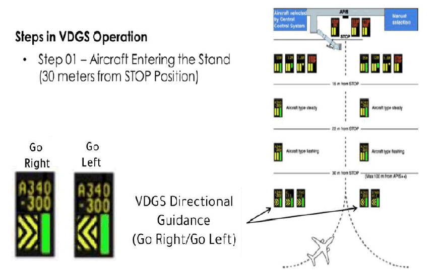
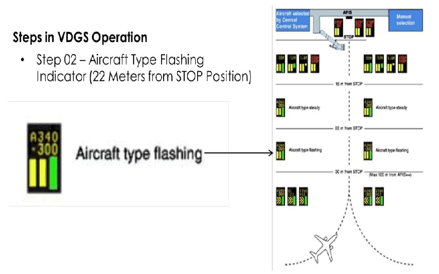
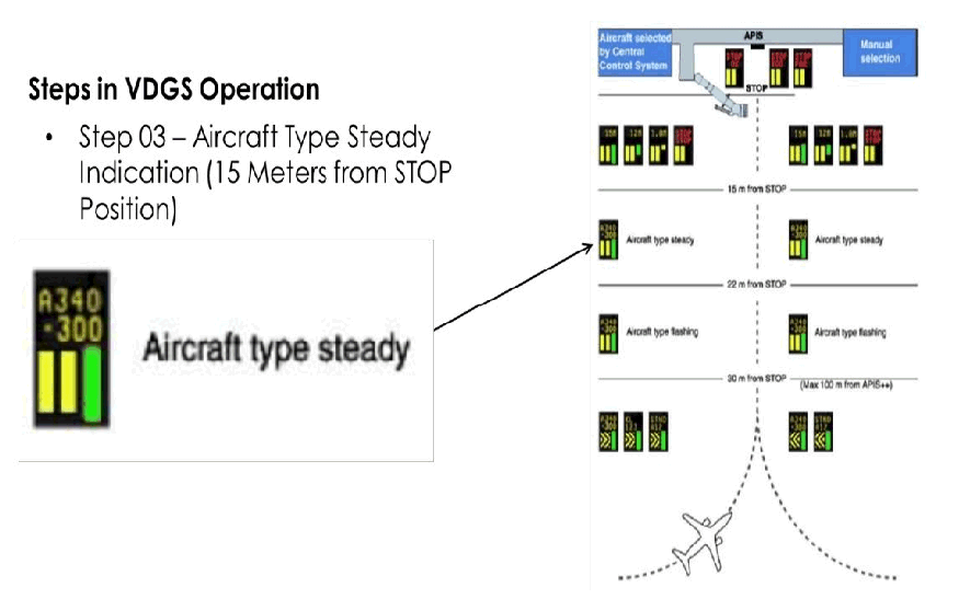
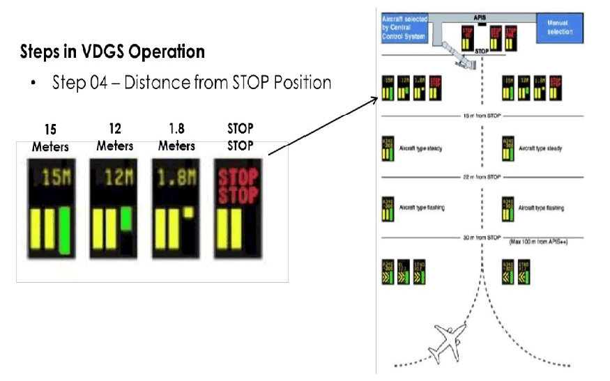
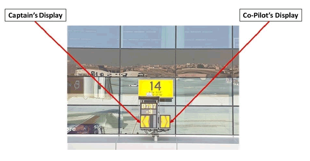
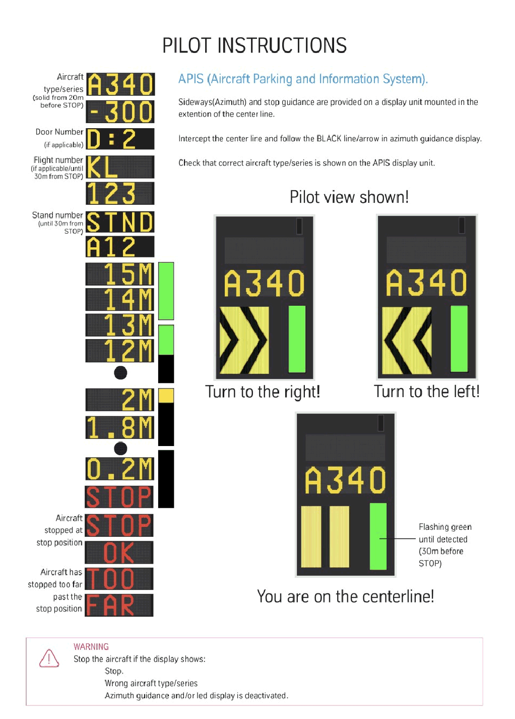
Visual Docking Guidance System (FMT – APIS)
1-FMT APIS Docking Process
| Step | Process |
| 1.1 | The following steps occur during the aircraft entry and docking process of the FMT APIS VDGS. |
| 1.1.1 |
 |
| 1.1.2 |
 |
| 1.1.3 |
 |
| 1.1.4 |
 |
| 1.1.5 |
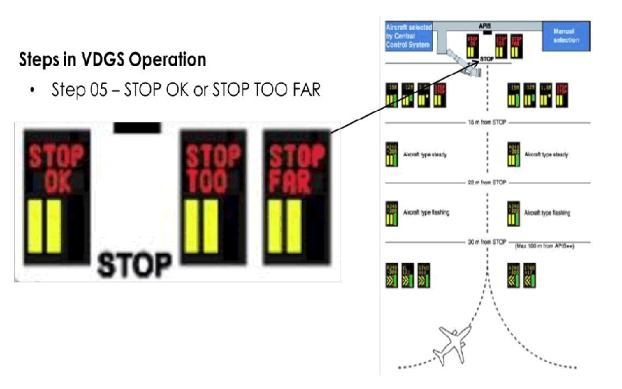 |
2-FMT APIS Azimuth Guidance – Cockpit View.
3- Pilot Instructions
OBBI AD 2.24 CHARTS RELATED TO AN AERODROME
|
Chart name |
Page |
|---|---|
|
AERODROME/HELIPORT CHART | AD 2-OBBI-26 |
|
AERODROME GROUND MOVEMENT CHART | AD 2-OBBI-28 |
|
AIRCRAFT PARKING DOCKING CHART MAIN APRON A | AD 2-OBBI-30 |
|
AIRCRAFT PARKING DOCKING CHART MAIN APRON B | AD 2-OBBI-32 |
|
AIRCRAFT PARKING DOCKING CHART MIDDLE AND CARGO APRONS | AD 2-OBBI-34 |
|
AIRCRAFT PARKING DOCKING CHART EXECUTIVE AND CARGO APRON | AD 2-OBBI-36 |
|
AIRCRAFT PARKING DOCKING CHART WESTERN APRONS A & B, AND CARGO & EXECUTIVE APRONS | AD 2-OBBI-38 |
|
AIRCRAFT PARKING DOCKING CHART NORTHERN APRON | AD 2-OBBI-40 |
|
AIRCRAFT PARKING DOCKING CHART EASTERN APRON | AD 2-OBBI-42 |
|
AIRCRAFT PARKING DOCKING CHART EASTERN APRON EXTENSION | AD 2-OBBI-44 |
|
AERODROME OBSTACLE CHART RWY 12L / 30R | AD 2-OBBI-46 |
|
AERODROME OBSTACLE CHART RWY 12R / 30L | AD 2-OBBI-48 |
|
PRECISION APPROACH TERRAIN CHART - ICAO RWY 30R | AD 2-OBBI-50 |
|
PRECISION APPROACH TERRAIN CHART - ICAO RWY 12L | AD 2-OBBI-52 |
|
AREA CHART BAHRAIN | AD 2-OBBI-54 |
|
DEPARTURE CHART (RADAR) RWY 12L | AD 2-OBBI-56 |
|
DEPARTURE CHART (RADAR) RWY 30R | AD 2-OBBI-58 |
|
CIRCLING AUTHORIZATION AREA | AD 2-OBBI-60 |
|
IAC - ICAO RWY 12L VOR DME ILS CAT A-D | AD 2-OBBI-62 |
|
IAC - ICAO RWY 12L VOR DME CAT A-D (L) | AD 2-OBBI-64 |
|
IAC - ICAO RWY 12L VOR CAT A-D (L) | AD 2-OBBI-66 |
|
IAC - ICAO RWY 12R RNAV (GNSS) CAT A-D(L) | AD 2-OBBI-68 |
|
IAC - ICAO RWY 12L RNAV GNSS CAT A-D (L) | AD 2-OBBI-70 |
|
IAC - ICAO RWY 12R VOR DME CAT A-D (L) | AD 2-OBBI-72 |
|
IAC- ICAO RWY 30L VOR DME CAT A-D (L) | AD 2-OBBI-74 |
|
IAC - ICAO RWY 30R VOR DME ILS CAT A-D | AD 2-OBBI-76 |
|
IAC - ICAO RWY 30R VOR DME CAT A-D (L) | AD 2-OBBI-78 |
|
IAC - ICAO RWY 30R VOR CAT A-D (L | AD 2-OBBI-80 |
|
IAC - ICAO RWY 30R RNAV GNSS CAT A-D (L) | AD 2-OBBI-82 |
|
IAC - ICAO RWY 30L RNAV (GNSS) CAT A-D(L) | AD 2-OBBI-84 |
|
VISUAL APPROACH CHART - ICAO | AD 2-OBBI-86 |
|
BIRD CONCENTRATIONS | AD 2-OBBI-88 |
|
RADAR MINIMUM ALTITUDE CHART | AD 2-OBBI-90 |
|
STAR CHART - ICAO RWY 12L/30R RNAV1 - RADIO COMMUNICATION FAILURE STAR | AD 2-OBBI-92 |
|
STAR CHART - ICAO RWY 12L/30R RNAV1 - DENVO 1 ARRIVAL | AD 2-OBBI-94 |
|
STAR CHART - ICAO RWY 12L/30R RNAV1 - KOBOK 1 ARRIVAL | AD 2-OBBI-96 |
|
STAR CHART - ICAO RWY 12L/30R RNAV1 - LADNA 1 ARRIVAL | AD 2-OBBI-98 |
|
STAR CHART - ICAO RWY 12L/30R RNAV1 - SOGAT 1 ARRIVAL | AD 2-OBBI-100 |
|
LOW VISIBILITY PROCEDURE - DEPARTURE RWY 12L-30R | AD 2-OBBI-102 |
|
LOW VISIBILITY PROCEDURE - ARRIVAL RWY 12L - 30R | AD 2-OBBI-104 |