GEN 3.2 Aeronautical charts
3.2.1 RESPONSIBLE SERVICE
Civil Aviation Affairs of Bahrain provides a wide range of aeronautical charts for use by all types of Bahrain Civil Aviation Affairs. The Aeronautical Information Service produces the charts which are part of the AIP. For addresses see GEN 3.2.3 below.
The charts are produced in accordance with the provisions contained in the following ICAO documents: Annex 4 - Aeronautical Charts. Differences to these provisions are detailed in section GEN 1.7.
3.2.2 MAINTENANCE OF CHARTS
3.2.3 PURCHASE ARRANGEMENTS
Aeronautical Information Management
P.O. Box 586
Kingdom of Bahrain
Tel:+973 17321180 / +973 17321181 / +973 17321182
Fax:+973 17323876
AFS:OBBBYNYX
The charts listed under GEN 3.2.5 of this section may be obtained through the following accredited chart agents:
Edward Stanford Ltd.
12 - 14 Long Acre, London, WC 2 E 9 L P., UK
British Airways (Aerad) (S 464),
P.O. Box 10, Aerad House,
Heathrow Airport
Hounslow, Middlesex
TW 6 2 JA, UK
Airtour International Ltd.,
Elstree Aerodrome,
Elstree,
Herts, WD 6 3 AW, UK
British Light Aviation Centre,
Artillery Manisions,
Victoria Street,
London SW 1, UK
3.2.4 AERONAUTICAL CHART SERIES AVAILABLE
World Aeronautical Chart - ICAO 1 : 1.000.000
Plotting Chart - ICAO
Aerodrome / Heliport Chart - ICAO
Aerodrome Ground Movement Chart - ICAO
Aircraft Parking / Docking Chart - ICAO
Aerodrome Obstacle Chart - ICAO - Type A
Aerodrome Obstacle Chart - ICAO - Type C
Precision Approach Terrain Chart - ICAO
En-route Chart - ICAO
Area Chart - ICAO (departure, arrival and transit routes)
Instrument Approach Chart - ICAO (for each runway and procedure type)
Visual Approach Chart - ICAO
Low Visibility Procedure Chart - ICAO
The charts currently available are listed under AD 2.24 of each aerodrome.
-
World Aeronautical Chart ICAO 1 : 1.000.000
The World Aeronautical Chart ICAO 1 : 1.000.000 series is constructed on Lambert Conical Orthomorphic Projection up to 80° N and Polar Stereographic Projection between 80° N and 90° N with the scales matching at 80° N. The aeronautical data shown has been kept to a minimum, consistent with the use of the chart for visual air navigation. It includes a selection of aerodromes, significant obstacles, elements of the ATS system, prohibited, restricted and danger areas and radio navigation aids. The chart provides information to satisfy visual air navigation and is also used as a pre - flight planning chart.
-
Plotting Chart - ICAO
This series, covering the North Atlantic, Western Europe and North Africa is designed for in - flight long range navigation and is constructed on Mercator‘s projection with simple outline of land areas at a scale of 1 : 5.000.000. Aeronautical data consist of major international aerodromes, selected radio navigation aids, lattices of long range electronic aids to navigation, FIR, CTA, CTR, reporting points, etc. The chart is designed to provide a means of maintaining a continuous flight record of the aircraft position.
-
Aerodrome / Heliport Chart - ICAO
The Aerodrome / Heliport Chart - ICAO contains detailed Aerodrome / Heliport data to provide flight crew with information which will facilitate the ground movement of aircraft:
-
from aircraft stand to the runway; and
-
from the runway to the aircraft stand;
and helicopter movement:
-
from the helicopter stand to the touchdown and lift - off area and to the final approach and take - off area;
-
from the final approach and take - off area to the touchdown and lift - off area and to the helicopter stand;
-
along helicopter ground and air taxiways; and
-
along air transit routes;
-
It also provides essential operational information at the aerodrome / heliport.
-
-
Aerodrome Ground Movement Chart - ICAO
The Aerodrome Ground Movement Chart - ICAO is produced for those aerodromes where, due to congestion of information, details necessary for the ground movement of aircraft along the taxiways to and from the aircraft stands and the parking / docking of aircraft, cannot be shown with sufficient clarity on the Aerodrome / Heliport Chart - ICAO.
-
Aircraft Parking / Docking Chart - ICAO
This chart is produced for those aerodromes where, due to the complexity of the terminal facilities the information to facilitate the ground movement of aircraft between the taxiways and the aircraft stands and the parking / docking of aircraft cannot be shown with sufficient clarity on the Aerodrome / Heliport Chart - ICAO or on Aerodrome Ground Movement Chart - ICAO.
-
Aerodrome Obstacle Chart - ICAO, Type A (Operating Limitations)
This chart contains detailed information of obstacles in the take - off flight path areas of aerodromes. It is shown in plan and profile view. This obstacle information, in combination with an Obstacle Chart - ICAO, Type C provides the data necessary to enable an operator to comply with the operating limitations of Annex 6, Parts I and II, Chapter 5.
-
Aerodrome Obstacle Chart - ICAO, Type C
This chart contains obstacles data necessary to enable an operator to develop procedures to comply with operating limitations of Annex 6, Parts I and II, Chapter 5 with particular reference to information on obstacles that limit the maximum permissible take - off mass. This chart must provide certain obstacle data and topographical information covering a distance of 45 KM (24 NM) from the aerodrome reference point.
Appropriate topographical charts which are available for the area around the airports, if supplemented with "overprint" obstacle data and other significant aeronautical information, should be suitable for use as the topographic base for the AOC - ICAO, Type C. The chart is not produced if:
-
The required obstacle data is published in the AIP; or
-
No significant obstacles exist, and this fact is published in the AIP.
-
-
Precision Approach Terrain Chart - ICAO
Precision Approach Terrain Charts - ICAO provide detailed terrain profile information within a defined portion of the final approach so as to enable aircraft operating agencies to assess the effect of the terrain on decision height determination by the use of radio altimeters. This chart is produced for all precision approach runways Categories II and III.
-
En-route Chart - ICAO
This chart is produced for the entire BAHRAIN FIR / BAHRAIN UIR. The aeronautical data include all aerodromes, prohibited, restricted and danger areas and the air traffic services system in detail. The chart provides flight crews with information to facilitate navigation along ATS routes in compliance with air traffic services procedures.
-
Area Chart - ICAO
The Area Chart - ICAO is produced where the air traffic services routes or position reporting requirements are complex and cannot be shown on an En-route Chart - ICAO. It contains in more detail aerodromes, which affect terminal routings, prohibited, restricted and danger areas and the air traffic services system. This chart provides the flight crew with information to facilitate the following phases of instrument flight:
-
the transition between the en-route phase and approach to an aerodrome;
-
the transition between take - off / missed approach and en-route phase of flight; and
-
flights through areas of complex ATS routes or airspace structure.
-
-
Instrument Approach Chart - ICAO
Instrument Approach Charts - ICAO are produced for all aerodromes used by civil aviation where instrument approach procedures have been established.
A separate Instrument Approach Chart - ICAO has been provided for each approach procedure.
The aeronautical data shown include information on aerodromes, prohibited restricted and danger areas, radio communication facilities and navigation aids, minimum sector altitude, procedure track portrayed in plan and profile view, aerodrome operating minima etc.
This chart provides flight crew with information which will enable them to perform an approved instrument approach procedure to the runway of intended landing including the missed approach procedure and where applicable, associated holding patterns.
-
Visual Approach Chart - ICAO
The Visual Approach Chart - ICAO is produced for aerodromes used by civil aviation where:
-
only limited navigation facilities are available;
-
radio communication facilities are not available; or
-
no adequate aeronautical charts of the aerodrome and its surroundings at 1 : 500.000 or greater scale are available; or
-
visual approach procedures have been established.
The aeronautical data shown, include information on aerodromes, obstacles, designated airspace, visual approach information, radio navigation aids and communication facilities as appropriate.
-
-
Low Visibility Procedure Chart - ICAO
Low visibility operations shall be declared whenever;
-
The tower controller’s ability to visually survey the manevering area is limited to portions of the maneuvering area, or
-
The RVR reading is 1000 m or below.
-
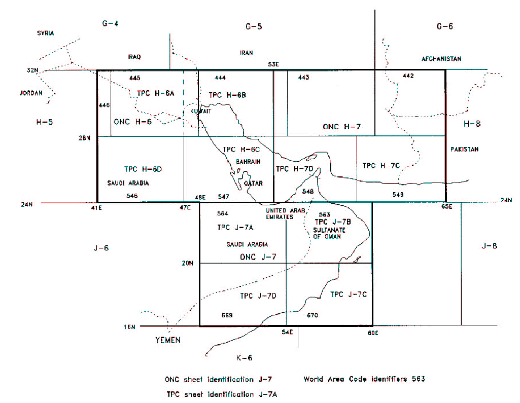
3.2.5 INDEX TO OPERATIONAL NAVIGATIONAL CHARTS ONC 1 : 1.000.000 and TACTICAL PILOTAGE CHARTS TPC 1 : 500.000
| LIST OF CHART SERIES | ||
|---|---|---|
| TITLE AND SCALE | SERIES CODE | CHART NUMBER |
|
Topographical Operational Navigation Chart - 1 : 1.000.000 | ONC | H - 6 |
| ONC | H - 7 | |
| ONC | J - 7 | |
|
Topographical Tactical Pilotage Chart - 1 : 500.000 | TPC | H - 6 A |
| TPC | H - 6 B | |
| TPC | H - 6 C | |
| TPC | H - 6 D | |
| TPC | H - 7 D | |
| TPC | J - 7 A | |
| TPC | J - 7 B | |
| TPC | J - 7 D | |
3.2.6 TOPOGRAPHICAL CHARTS
To supplement the aeronautical charts, a range of topographical charts is available from:
The Ministry of Housing
Survey Directorate
P.O. Box 5802
Kingdom of Bahrain
Tel:+973 17533000
Fax:+973 17533795
3.2.7 CORRECTIONS TO CHARTS NOT CONTAINED IN THE AIP
NIL